Followers

Saturday, 13 May 2017

Stoodley Pike


It was a lovely day – a little windy but I’d been wanting to walk up here again for ages.  Today was the day, but I chose a shorter route than the one I had taken last time was up here.  My last walk up to Stoodley Pike had been from Todmorden and I had a lot more time to do the walk.  Today I only had a few hours in the afternoon so I was starting out from Lumbutts which would make the walk considerably shorter. Parked up just a little lower down from the pub and set off up the track.  This then joined the walled track – flagged up onto the moor. 


The pathway was clear all the way up – however on reaching the top you lose sight of the Pike and on arriving at the crossroads of paths – how I missed the stoop an ancient guidepost I have no idea but I blithely carried straight on.  Eventually when I kept thinking I should surely be able to see the Pike by now I stopped and looked back.  I could see a steady stream of walkers heading across the moors from my left to right. I then had to re-trace my steps back to the crossroads this time turning to my right.  Within minutes there was the Pike in front of me.


 As I got up to its base the wind was picking up.  There were several people who had gone up inside the Pike to come out and walk around its viewing balcony and because I hadn’t gone up there last time I was here today I decided I would. I was glad of my little torch on the way up the 39 steps to the viewing area. It was pitch black inside. When you looked out over the views it was worth the climb.  It was surprising how much more windy it was up here.  Those few steps up made a huge difference. 


After walking all the way round I went back down and started the journey back down off the moors.
 I dropped past the Doe Stones onto a broad track taking you beneath the Pike. 
 This is known as the London Road which eventually comes out by Mankinholes a YHA stopping point for walkers on the Pennine Way.
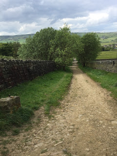


 From here it was a straight walk back to where I’d left my car.

4 ½ miles of bracing air, you can’t beat it

Sunday, 7 May 2017

Bolton Abbey - Embsay

It was another nice day, what to do with the children?  Eventually we decided to go to Bolton Abbey catch the train to Embsay and – guess what meet Peppa Pig. 


We set off and all the way there George said he thought this was going to be so boring.  That is until we parked up and boarded the train.  They were those lovely old fashioned individual carriages with a corridor running down the side.  Very exciting.  The train ride was lovely and just long enough to not get bored.  We hopped off the train and had a look around Embsay train station then got back on for the ride back. 

  When we got back Peppa Pig was there to meet us, Mabel was sooo excited. She couldn’t wait to have her photo taken with Peppa.


We then took off to Embsay Reservoir, Bernard had been very good sat in the car while we were on the train and he needed a run out now.  


It was pretty busy up at the reservoir, lots of dog walkers and families but the children really enjoyed the walk around and so did Bernard. It was a nice leisurely one mile saunter just enough for everyone to let off steam without getting over tired.

A brilliant family day out. 

Cam Head

It was a pleasant day today and I felt like a change.  A run up into the Dales, and a new walk.  This walk starts in Kettlewell, and although I thought I had got there pretty early a lot of the car parks were already full.  Eventually found a small space and went and paid my £2 to garage.
Set off past the Racehourse Inn and took the road out of the village. Uphill straight away, why am I not surprised.  The direction was as the road went right I should continue straight ahead.  Uphill.
IMG_2314
This is Top Mere Road, the book says a relatively steep start so stop and admire the view.  There was going to be a lot of that.  As I kept on up and up I could see Great Whernside to my right.  I did that last year and that had left me with a sense of achievement – I could see the Hag Dyke Scout building on the hillside.


Eventually I came to a signpost at the top, the book said there was a cairn but this has since been replaced with the signpost.  I asked a couple who were coming up behind me and they confirmed I was on the right track and should bear left and take the path that was turning back on itself slightly. The summit it 1706ft 520 mts so not as high as Great Whernside, but still a stiff climb.
IMG_2320
The green path goes along level for a short way and then begins the slope back down. I joined the road back down – this is called Starbottom Cam Road.  It’s a horrid road, all rolling stones and pebbles, like the one down from Buckden Pike.  As I kept walking down I looked across and could see the similar road which runs down from the Pike.   Eventually coming into back lane at Starbottom.


To return to Kettlewell from here I turned left along the road and then took a footpath down to the river, crossing it and taking the Dalesway path all along the valley bottom which then brought me back into Kettlewell.

Saturday, 6 May 2017

Ponden Circular

Well originally I had been going to go over to Colne and do a walk there but I was late setting out and I’d been full of cold all week so I decided to stay closer to home.
Parked up at Ponden Reservoir banking and walked up past Ponden Hall and took the same pathway I’d taken a few weeks ago with the family.  It was pretty breezy up on the tops, this would certainly clear the bugs and blow the cobwebs away.  When I got up to the kirk top the wind was pretty chilly too.  There were lots of Grouse flying up out of the heather and lapwing flying around. 


  However on this walk instead of going across past the Kirk stones and then taking the steps back down to the water board track I carried along the top of the hill following the narrow track, eventually Buckley Green came into view.  Here instead of going through the stile, I headed right back up onto the moor eventually joining up with the broad Pennine Way track I followed this straight up to Top Withins. 


  As I neared the top I could see lots of walkers heading my way from the direction of Heptonstall/Warley.  As I went round the back of the Top Withins ruins there were two marshals.  A long distance walk of 20 miles apparently and this was their last check point.


Anyway I headed back down the hill and then took fork off to the right and followed the clear pathway which eventually brought me to the hill at the top of Bronte bridge and waterfalls.  I decided not to walk down to the bridge but cut back across a field which brought me back on the Pennine Way track and across to Buckley Green.  Following the track past the houses until I turned down a narrow path which looked like an old cart track – bringing me back to the Reservoir banking and my car.

A good 6 mile tramp across the moors, that should hopefully killed a lot of my cough/cold bugs.  Just wish it had been a little warmer, it was too cold to linger today.