Followers

Saturday, 2 September 2017

Ramshaw

 It was a beautiful day around 17/18 degrees and feeling really warm I have walked around here before but using a different walking book which gave directions for a 2 ¾ mile walk.  The book was using today gave directions for a 4 ¾ miles so hopefully I’d go somewhere a little different.  The walk set off from Carleton and took me up a side road called the Wend.  This was familiar territory.  Passing a lovely old barn on the right I went through a field and followed the line of the beck through the fields to drop down and cross over the beck. 

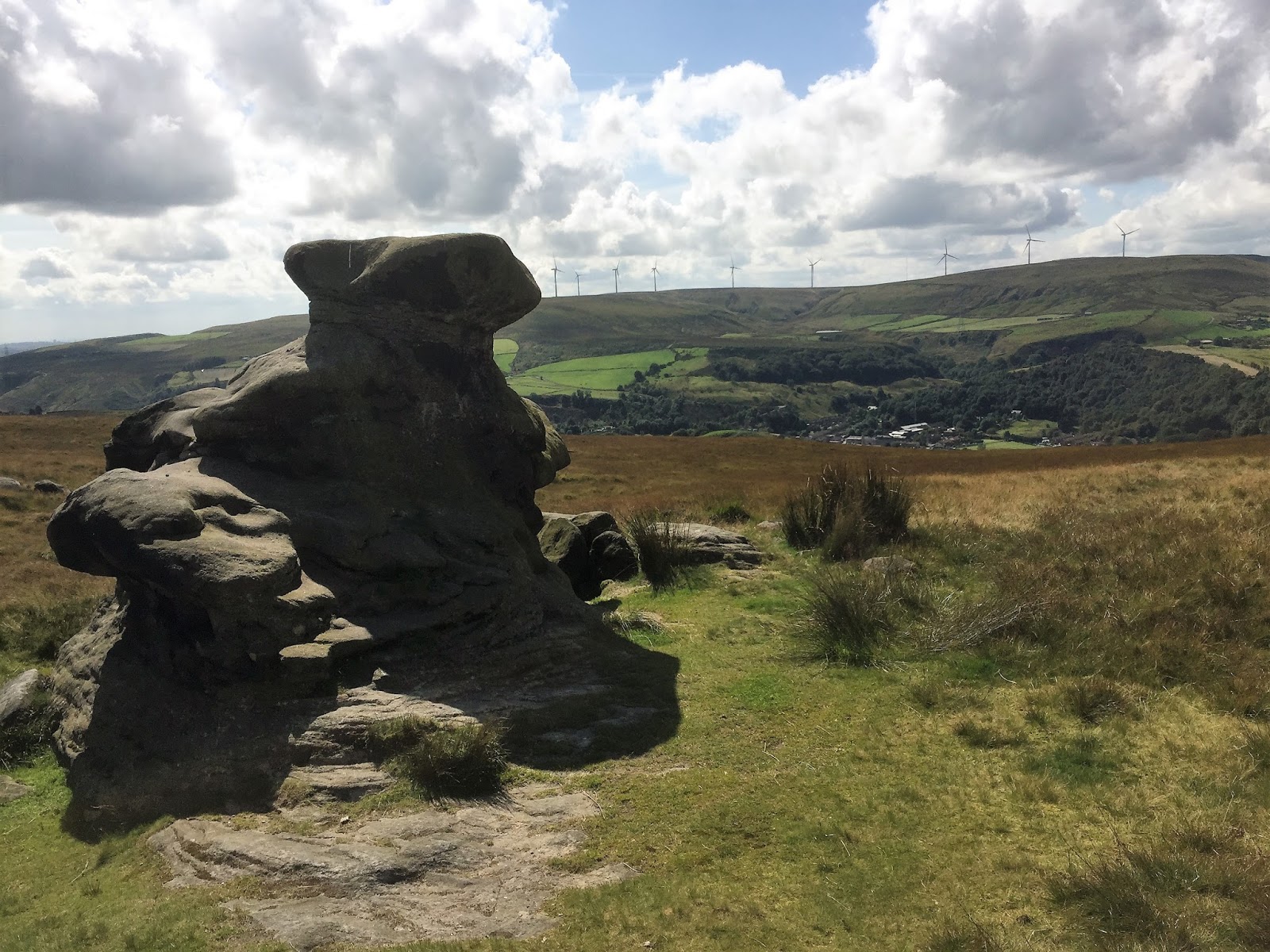
  Climbing up the other side looking back the views were stunning today.  I could see Cracoe war memorial and Rhylstone cross on th skyline with Crookrise cragg behind.


The next 15 minutes were pretty much uphill to Gawthorpe House – from here I took a downward track to where I wasn’t sure which way to go I took a right turn to eventually reach a wall where there was supposed to be a stile into the road. 

No Stile.  I didn’t want to go all the way back so found a wall with good stones to scramble over. Out on the road referred back to book and took the instructions to go left at T junction.  Going down here I actually found the right stile and looking back could see where I should have gone. 

 I could also see a large field full of goats which is not something you often see.  I now referred back to book.  Directions now meant re-trace steps back to T junction and bear left down a different road.  After a short while I turned off the road to Tewit Cote farm road.


Here were a group who at first I thought were having a picnic but as I went past I suddenly heard a loud buzzing and looking back they were flying drones and using large hoops in the ground as a course to take the drones through.  They were a lot louder than I thought they would be, as I stopped to watch they seemed to be racing one another and were going a lot faster than I thought they would too. Suddenly one of them crashed into a hoop. Time to be on my way I think.  

I turned off the grassland through a stile and back onto moorland.  

As I came to a dip there was a crossroads of footpaths and settled on the one ahead, I hadn’t gone far when I thought Id check the way on my OS map on my phone – yep as I thought I’d gone wrong – retraced my steps back to the crossroads and went through a gate, the way was obvious now a well-used trod made its way through the heather eventually dropping down a path I had been on before on other walks. 


 From here through fields to emerge on Carleton Biggin drive, 

down to a stile on the left through a couple more fields onto a lane and back down the road into Carleton.  Good walk made into a 5 miler with my two or three wrong turns.  I was really warm now the day had just got warmer as the afternoon went on. I was ready for a drink and tea.

Monday, 28 August 2017

Skipton Woods


 This wasn’t really about a good long walk this was more a happy amble so I could play about with the light and my camera, rather than just taking photographs on my phone.  I do love photographing things and never really get the time to “mess about”.  So today I decided to have a wander around Skipton Woods, I had never been before so that made it interesting in itself.
I entered the woods from just beside the Castle walls and the path is well concreted and suitable for push chairs and little ones.  As I wandered along there were lots of mini waterfalls to the side. 

The trees overhead cast lovely green reflections in certain parts.  It really was lovely. The walk went around in a loop and came back to a small dam.


 The walk back was then pretty much the way I had come.  There were lots of families out and about and quite a few dogs enjoying splashing around in the water too.


A very pleasant 2 ½ mile walk.  Lovely.


Sunday, 27 August 2017

Windgate Nick

Today I’m walking with Bradford Council guided walks. We met up at 11am at Wesley Place Silsden.  It was beautiful weather – feel lucky it’s a bank holiday and good weather.  I have been up to Windgate Nick before but from the Addingham side so this was a change.  We started off along the canal.  

This is a lovely part of the canal with some pretty houses along the way.  After about ¾ mile we turned off and crossed over the canal heading up a track to some farm buildings – crossing a road and walking alongside a golf course.  I have walked here before around Swartha and Brunthwaite. However once we had crossed the golf course the walk went in a different direction and we started the pull up to the top of the moors.  


We went up through a field to come out onto a country road.
As I looked up there were people taping off areas of rocks and hill climbs – this is motorbike trialling/scrambling and there must be a meeting tomorrow that they were preparing for.  The sections taped off looked horrendous – they would be hard enough to walk up never mind go over the routes on a bike.  It was interesting see though.


From here it was over a stile and steep pull up to the seat and the plaque at the top.  This is where a de Havilland mosquito plane crashed in WW 2 – it got off course and the RAF pilot was looking for familiar landmarks to finds its way home after it had completed its mission when it caught the hill tops and spun into a dip in the moors. 


We stopped here for some lunch – it was quite cool and breezy up here.  After lunch we walked along moorside – the tops of the crags to then begin the long walk down.  In parts this was a little tricky, I had to keep my eyes on where I was walking as we were going down over rocks and narrow tracks.


At the bottom we went down through some fields to eventually arrive at Brown Bank Caravan site.  We walked through here; the static caravans were lovely with gardens and decking around them, very peaceful.  On leaving here we continued down through fields and past some garden allotments to eventually bob out on the main road through Silsden – from here we just walked back down the road the car park.  A very good 7 ½ mile walk and back down in Silsden it was lovely and warm again.  

Saturday, 26 August 2017

Salter Rake

The forecast was good for today although around lunchtime there was a small squally shower. Other than that the day was perfect.  Today I headed off to Todmorden to walk up around following the historic packhorse path. 
That was the plan anyway – it didn’t turn out quite as planned but never mind it was a great day.The way forward was clear to start with – up Honey Hole Road, passing an old classic car on the way. 


The path was steep but pretty straight forward passing a Quaker burial ground on my right.


Eventually came out by the Shepherds Rest pub.


 From here the directions were go straight across through the stile and onto Langfield Common – the direction said after a minute bear right onto the well preserverd causeway of Salter Rake.  I couldn’t see it – lots of people were going straight up the hillside, no one was going on a path to the right.  So I decided to follow the crowd, this was half an hour of steep up hill walking. As I got near the top I realised where I was Gaddings Dam.  At least I knew where I was now.


So I decided to walk along the Dam banking to the right and then take a path down from the right-hand corner. I knew there was a path there as I’d taken that path before.  As I walked along the banking I saw a man towards the end taking his shorts off – I thought nothing of it really just assumed he’d been swimming and was drying off before getting dressed. Oh no – he proceeded to lay a towel out and lay in the sun – wearing nothing but a hat. As I walked past him I kept my eyes on the footpath and focussed on the way forward.  Surprising what you see when you’re out isn’t it. At the end I turned down and came to a familiar boulder, the path continued down to the crossroads of paths that were mentioned in the walk.

 So I was now back on track – I’d merely taken a detour up to the dam.  Turning left on the Salter rake and the stone slabs – the pack horse route taking salt over the pennines from Cheshire.  From here is was a steady walk down to a small hamlet and continuing down to a house dated 1805 where a Nobel prize winning scientist lived – Sir John Cockroft.


The way back from here was along the Rochdale Canal. The book said 4 ¼ miles but seeing as I’d gone wrong it had become a 5 ½ mile walk.  It was good I’m glad I went wrong and found Gaddings Dam again.

Sunday, 20 August 2017

Ilkley North of the River


Yesterday had been a wash out for walking I’d driven up in the dales and every time I thought that maybe it was going to fair up 10 minutes later it had rained again. Today the sun was shining and I packed some lunch and set off to meet up at Ilkley Lido with the Bradford Council Guided Walkers Group. The day was set fair and there were 16 of us a good group.  Some I recognised from previous walks I’d done with this group in the past. Phil the leader and the Ken the back-up were both people I recognised. 
The first part of the walk was up through Middleton Woods just a steady pull emerging into a sunny field with a huge oak tree in the middle. 

We then carried on up the field to a small tarmacadam lane leading to a beautiful farm.  From here we went through a field towards Fairy Dell.  Phil suggested we keep our eyes peeled for any fairies, sadly we didn’t spot any.  


From here we arrived in a large field where we stopped for lunch. One sheep came over to see what we were up to but as soon as I got my camera out to take its photo it moved off – clearly camera shy (sheep are extremely photogenic and nearly always make a good photo for some reason). 


As we headed up the fields we looked across the heather moor and could see Beamsley Beacon in the distance. A little nearer was March Gill Reservoir and up ahead we could see two or three Red Kite hovering around. 


We eventually came onto a small lane down to another farm gate which took us back up onto the moor along a pretty boggy pathway to eventually go through as stile to drop back down onto a narrow back lane. 


  These pathways were not well used there were no trods in the fields so you wouldn’t have known they were public access just by looking.

This back lane quickly brought us into the small hamlet of Denton – every house here is just beautiful. 


From here we made our way back through the fields down onto Denton Old Road and back into Ilkley.  A lovely 8 mile walk, made up for yesterdays let-down,